1 Introduction
Town Planning Collective have been engaged by the residents of the Michael Creek Valley Action Group to review the application for a material change of use for a proposed battery storage facility and other associated applications. Our review of the DA application has been based on the information that is available from the Council’s website.
2 Background
2.1 Site Description
The Planning Report submitted with the application provides the following details in relation to the subject site:
The project site is comprised of five individual allotments which are located 35 kilometres south-west of Ingham, on the Seaview Range in North Queensland, as shown in Figure 2 below. Combined, the project site has a total area of 3,185 hectares and forms the western boundary of Hinchinbrook Shire Council Local Government Area. Generally, the project site is bound by Blackbutt/Knuckledown Road in the north, Ewan Road in the East and Furber Road in the South and West.
Specifically, the application comprises the following lots as reflected in Figure 3:
- Lot 592 on SP302249 upon which the bulk of the BESS and associated infrastructure is located within the north-west portion of the subject lot including lease area and associated access easement to Knuckledown Road (to the north).
- Lot 591 on SP302249, which adjoins the main project site to the south-west and is included for the purposes of connecting the project substation and BESS to the Guybal Munjan Switching Station, which is located entirely within Lot 592 on SP302249.
- Lot 18 on WU6, which is located to the north of Lot 592 and will contain the permanent northern access and associated lease or easement.
- Lot 592 on SP302249, Lot 3 on WG274 and Lot 57 on SP237064 which will include temporary construction access for the development. The majority of the proposed eastern access track is to be located within Mountain Ash Road; Spotted Gum Road, Knuckledown Road and Furber Road road reserves; however there may be a requirement to construct accesses outside of these gazetted road reserves. Accordingly, these lots are included for the disturbance to vegetation required for access only, with no permanent infrastructure or tenure required for the project.
Topographically, the site is undulating with several mountains within and adjoining the site including Mount Fox to the west and Mount Ryan to the south. The majority of the sites are heavily vegetated, with cleared sections within Lot 57 and Lot 3 containing homesteads and rural outbuildings associated with cattle production. The Guybal Munjan Switching Station is located within Lot 591 adjoining the Ross to Cairns Transmission Line which traverses Lots 591 and 592 along the western section of the property.
There are several dedicated road reserves which traverse the site and an Easement (Easement A on CP805060) which traverses Lots 591 and 592 in a north-west/south-east direction and contains the Ross to Cairns Powerlink Transmission line and a smaller, Ergon transmission line traversing the northern portion of the project site within Lot 18 on WU6, Lot 57 on SP237064 and Lot 3 on WG274, although not included within an Easement. In addition, there is a Road License (Lot 1 RL2631) over part of Mountain Ash Road which bisects the project site (between Lot 18 and Lot 592); and a Road License (RL3694) bordering the northern boundary of Lot 57 within Bluckbutt Road. Both Road Licenses are understood to relate to cattle grazing and associated covenants are in place to secure their connection to the adjoining land.
It is understood that surrounding sites are primarily used for cattle grazing, electricity transmission and smaller mining tenures. Surrounding the site to the east and north are smaller freehold landholdings and Mount Fox National Park to the north west of the site and Girringun Forest Reserve to the north east. To the west are larger pastoral holdings.
Pursuant to Hinchinbrook Planning Scheme 2017, the project site is mapped as being within the Rural Zone and is influenced by various overlay matters. Part of the project site (Lots 591 and 592 on SP302249 and Lot 18 on WU6) is also mapped as being within the Solar Energy Development Precinct.
2.2 Proposed Development
The Planning Report accompanying the application provides the following description of the development:
While the MFEP BESS will form part of the overall Mount Fox Energy Park project, it is intended to be developed separately to the Wind Farm project. The Mount Fox Energy Park is expected to generate up to 350 Mega Watt (MW) of wind energy, which is sufficient to support many of the surrounding local communities, land uses and industries.
The BESS itself includes a battery system capable of both storing and exporting electrical energy and is electrically connected to the national grid (via a substation). Electrically, this includes changing voltages and both importing and exporting electricity into the grid. Technically, a battery system is both a generator (when it exports electricity) and a load (when it imports from the grid). The purpose is to absorb excess electricity for re-use during peak demand periods. In this way, the battery and substation work together to regulate electricity as well as switch the voltages up and down to smooth the supply of electricity to the transmission grid. It is noted that the BESS originally formed part of the existing wind farm approval. It is now intended that construction and operation of the BESS is to occur separately from the wind farm. Additionally, the proposed BESS will not be constructed in the same location originally approved. The requirement to move the substation and BESS resulted from the subdivision and sale of the portion of land in which it was originally intended to construct these components.
Development for a BESS is defined as a ‘Battery Storage Facility’, within Schedule 24 of the Planning Regulation 2017 and constitutes a ‘new use’ for the purposes of Planning Act 2016 as outlined below.
Battery Storage Facility is defined as:
Means the use of premises for the operation of 1 or more battery storage devices. Battery Storage Device is defined as:
(a) Means plant that –
- Converts electricity into stored energy; and
- Releases stored energy as electricity; and
(b) includes any equipment necessary for the operation of the plant.
Advice was sought in relation to the appropriate land use definition for the proposed Mount Fox BESS from the Department of State Development, Infrastructure, Local Government and Planning and the relevant Local Government Authority, that being Hinchinbrook Shire Council. Both entities confirmed that the proposed Mount Fox BESS would be most appropriately defined as a Battery Storage Facility in this instance. A copy of pre-lodgement advice is provided in Attachment 3.
The proposed MFEP BESS will consist of several components, the details of which have been provided below:
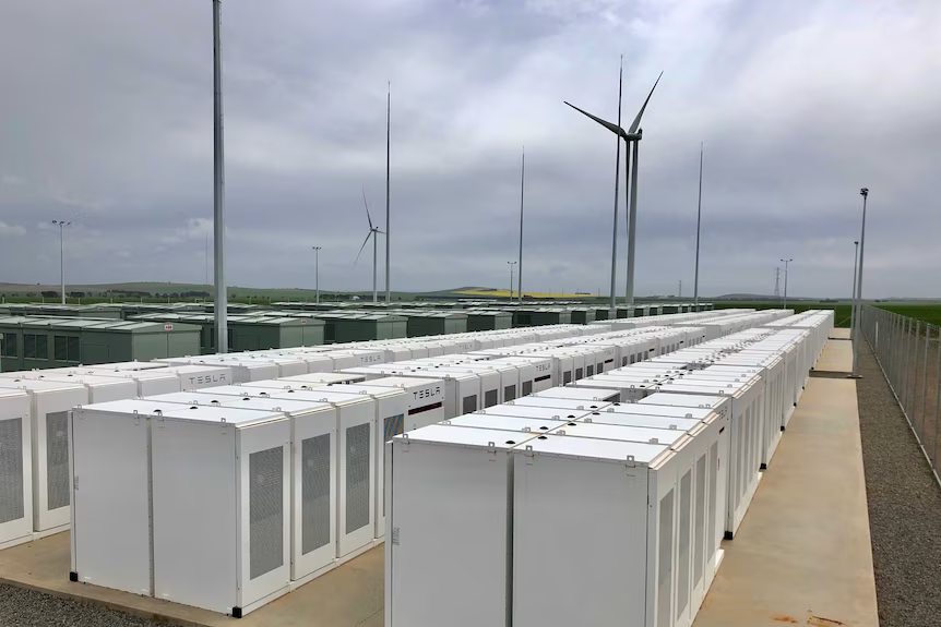
- BESS Megapacks – the size of the BESS is 300MW providing 600MWh of power through 164 x Tesla Megapack XL 2.0 and associated medium voltage transformers and Ring Main Units (RMU) located entirely within the proposed lease area within Lot 592 on SP302249. Dimensions of the proposed Megapacks to be utilised are provided in Attachment 4 – Proposal Plans.
- BESS Substation and associated infrastructure – power will be stepped up from 33kV to 275kV via transformers and associated substation infrastructure located entirely within the proposed lease area within Lot 592 on SP302249. Plans depicting the general arrangement of the Mount Fox Energy Park BESS Substation and associated infrastructure, as well as elevations, have been provided in Attachment 4 – Proposal Plans.
- Operations and Maintenance Infrastructure – the operations and maintenance facility will likely consist of an office trailer, with enough desk space to accommodate a maximum of seven (7) people; amenities, kitchenette facilities and a staging area and will be contained within Lot 592 on SP302249. Detailed requirements/specifications relevant to the operations and maintenance facilities are provided in Attachment 4 – Proposal Plans.
- Transmission Line – the BESS substation will connect to Guybal Munjan switching station via an overhead transmission line (‘OHTL’) spanning approximately 700m. The transmission line extends south-west, from the proposed BESS Substation on Lot 592 and extends into/traverses Lot 591 on SP302249, ultimately connecting to the Guybal Munjan switching station owned by Powerlink. The location and extent of the transmission line is detailed in the proposal plans included in Attachment 4. It is noted that Powerlink will be responsible for the construction of the transmission line component and will eventually become the registered owners of the lease and/or easement created to formalise access to/use of the transmission line. As such, no formal tenure is proposed over this component.
- Temporary construction/laydown area – a small area, located west of the proposed MFEP BESS access track, will be used as a temporary laydown area during the construction phase. This area will be appropriately rehabilitated upon completion of construction of the MFEP BESS and is contained within Lot 592.
- Access – Formalised access to the MFEP BESS – Access tracks are proposed to be constructed/formalised and form part of the proposed Mount Fox BESS. The main MFEP BESS access will be provided north of the BESS traversing the portion of Mountain Ash Road that has been temporarily closed, extending further north, through Lot 18 on WU6, ultimately connecting to Knuckledown Road.
- Access – informal/temporary access to facilitate construction of the MFEP BESS – Temporary access to the MFEP BESS will be established via the ‘east-west’ access track. The proposed alignment of the temporary east-west access is expected to utilise existing road reserves where possible (Mountain Ash Rd; Spotted Gum Road; Knuckledown Rd; and Furber Rd), as well as traverse through several freehold lots (Lot 57 on SP237064 and Lot 3 on WG274). The proposed alignment of the temporary east-west access track has been detailed on the proposal plans included in Attachment 4 – Proposal Plans. It should be noted that the east-west access will not form part of the MFEP BESS development and will only be used to facilitate construction of the MFEP BESS. The east-west access will be formalised, and will likely form part of the Wind Farm component of the Mount Fox Energy Park, at a later date. Accordingly, no formal tenure is proposed over this section, however the establishment of the roads and vegetation clearing is proposed as part of this application.
3 Planning Assessment
The following planning assessment is based on the limited site specific and development specific information available for the application.
3.1 Bushfire Risk
The bushfire report that accompanies the application provides an assessment of the bushfire impact of the development but provides no particular assessment of the bushfire risk that can emanate from a malfunctioning megapack. It is also noted that the bushfire report primarily focuses on the wind turbines rather than the BESS and infrastructure.
It is considered that the bushfire report overlooks a fire that could be started as a result of a malfunctioning BESS and due to the topography of the site could result in a substantial bushfire under certain conditions.
The bushfire report recommends the BESS site be equipped with a 40,000L water storage tank exclusively to be used for firefighting purposes. It is noted that the BESS contains lithium-ion batteries which are considered to be a class B flammable liquid and once ignited cannot be easily put out by traditional fire fighting methods. Lithium has a high ignition point and due to the battery being self-oxidizing, produces its own oxygen fuel source once ignited. To extinguish a lithium-ion fire the battery needs to be cooled below the sub-ignition temperature which occurs once the fuel source is depleted. The addition of water to a fire burning with such intensity will only cause the water to vaporise rather than dousing the fire to extinguish the flame. The result is, that lithium-ion fires must burn themselves out which runs the risk of the fire spreading to other megapacks and to the general area surrounding the fire.
The Mount Fox Energy Park website provides a case study of the Victorian Big Battery fire which was a result of a malfunctioning megapack. The case study provides a timeline of the fire noting the fire brigade was able to get to site within 15 minutes of the fire first being observed. The fire was left to burn itself out over the course of 6 hours and resulted in two megapacks burning during the event with the fire spreading from one megapack to the adjoining megapack due to the windy conditions. The report goes onto to state that a mitigating circumstance for the fire that avoided further impacts was the proximity of the fire brigade which was located 4km from the battery facility.
When considering the above information in the context of the site it is considered that the nearest bushfire brigade equipped to handle a fire at the facility is located at Ingham which is located approximately 55km from the BESS site. Additionally, the installation of a water storage tank for firefighting purposes will only protect the BESS from external bushfire events and cannot be used in the event of a fire emanating from the BESS itself.
It is considered that based on the isolated location of the BESS, a lack of onsite staff to adequately monitor and maintain the facility at all hours (unlike the Victorian Big Battery terminal) that the location of the BESS is considered to be unacceptable and should be located closer to adequate emergency services to provide instant support in the event of a lithium-ion fire.
3.2 Ecology
The proposed material change of use for the sites provides limited information regarding the impacts the development will have on the ecology of the area. The report provides broad sweeping statements regarding the development having no impact on the area from an ecology perspective but provides no detailed reporting. It is noted that the prelodgement meeting advice (attachment 3 of the planning report) highlighted that amended reports would be required for the new BESS location as provided in the extract below:
Figure 1: Extract from the Pre-lodgement advice provided in the Planning Report
The documents listed on Council “Have you say” website do not provide any additional reports and have no references to the original reports aside from superficial mentions of reports and studies. It is considered that site specific reports be provided for the BESS location as the modified area for the BESS was not part of the original State approval.
The extract of state mapping below shows that the site is considered part of state biodiversity significance however no assessment has been provided to assess the impact.
Figure 2: Mapping showing the biodiversity significance of the site
It is noted that the area is characterised by its intrinsic link to the natural environment and is a fundamental feature for the community that needs to be retained and protected. The assessment of the application cannot be completed without reports to assess the impacts on the natural environment which are further expanded on below.
Impacts on Michael Creek
The report provides contradictory information regarding the natural features of the site with the report stating that the site contains no water courses in some sections and then providing details of impacts on watercourses. The details provided in the report are broad statements with no detailed assessment provided. It is noted, as shown in the extract of topographical mapping (shown below) the site contains two streams that are tributaries of Michael Creek which are located within 100-300m of the selected BESS site. The streams are both located downhill from the BESS site to the west and north and while it is noted that the two streams may not have water flowing at all times of the year, due to the climate (being a tropic environment with consistent periods of heavy rainfall) these streams are essential for water runoff during storm events as part of a larger catchment. It is noted that the principal source of clean, freshwater for the local community of Mount Fox is groundwater, particularly via Michael Creek and a major concern is raised by the community regarding the impact the BESS and associated infrastructure will have on the community’s water supply.
Figure 3: Mapping showing the topography of the site and the streams located on the BESS site.
It is requested that an ecological assessment is provided to assess the impact of the development on the local water courses with water quality impacts including impacts relating to sediment and erosion regarding the clearing of vegetation.
Impacts on Wildlife
The proposed development will result in a large area of clearing of native vegetation for the new location of the BESS and associated infrastructure. It is noted that the planning report does not provide any detailed assessment on the impact of the clearing on the local wildlife. The site is located within Koala District C and does not provide any details regarding the impact the clearing will have on the koala habitat for the area. Additionally, based on discussions with the local community it is considered that the area is a habitat for local wallaby populations and other critical fauna that is a fundamental part of the surrounding ecosystem. It is recommended that an ecological assessment and a fauna management plan be provided to address the clearing and future use of the site to provide an adequate assessment of the impacts.
Figure 4: Mapping showing the site being located within Koala District C
Impacts on vegetation
As mentioned previously in this report, the proposed development requires substantial clearing of native vegetation for the construction of the BESS and associated infrastructure and only a broad assessment has been provided regarding the clearing. It is noted that the prelodgement advice provided details that site specific assessment of the native vegetation clearing needs to be provided to conduct an adequate assessment of the impacts. It is noted that if the development were to proceed based on the information submitted, it unknown whether critical endangered vegetation will be removed, and critical micro ecosystems destroyed.
It is requested that an ecological assessment be provided with substantial field studies and mapping to assess the impact of the clearing and ensure that any clearing will not result in the destruction of critical ecosystems or species.
Figure 5: Mapping showing the site being located the dominant area of concern within the precleared biodiversity area.
3.3 Character of the area
The Mount Fox area is characterised by large rural lifestyle lots within a dense landscape with undulating terrain providing local tributaries to Michael creek which provides drinking water for the area, in addition to local bores. The area surrounding the Mount Fox community to the south consists of large land holdings dense native remnant vegetation that are devoid of built features such as dwellings or other infrastructure. It is considered that while the area is zoned rural, the rural lots are located to the north of the subject sites adjoining Michael Creek.
The planning report provides the following comments regarding the development’s impact on the character of the area:
“it is noted that the primary rural (pastoral and cattle grazing) land use will continue into the future. Proposed development is not likely to impact on existing rural land uses and furthermore is considered to value add, given that the two different land uses can continue to be carried out in the same location, with no significant impacts to either operations. It is for this reason that proposed development is considered to be complimentary to the character of the area.”
It is suggested that the character of the area is best defined as being rural land surrounded by large native vegetation rather than specifically rural pastural land. The proposed development seeks consent for a material change of use of the site for a battery energy storage system (BESS) and associated infrastructure. The current proposal includes substantial clearing of native remnant vegetation to facilitate the BESS project. It is considered that the clearing of vegetation and material change of use is not considered to be within the character of the area particularly when considering the proximity to the Mount Fox Switching Station. It is considered that the proposed BESS in conjunction to the location of the adjoining switching station will result in the appearance of an industrial estate resulting in a substantial impact on the character of the area. It is also noted that the material change of use relates to the larger land holding and will not prevent an intensification of development subject to future approvals. There is a deep concern within the community that the proposed development will result in collation of services and facilities in the future to compliment the electrical distribution network.
3.4 Future Use
The material change of use relates to the larger land as a whole, rather than the 6ha area that is intended to be used for the BESS. As detailed in the character assessment of the site it is a concern for the community that if the BESS is approved, the electricity infrastructure will intensify as demand increases and open the opportunity for collation of complementary businesses and services for the electricity generation including production facilities and warehouses. This will result in Mount Fox area having its own electricity generation industrial park as well as resulting in substantial increases in land clearing and degradation.
3.5 Traffic
The planning report does not provide any details of traffic studies that have been undertaken for the proposed development including the construction process and overall operation of the site. A traffic impact report has not been provided to detail vehicle movements, the adequacy of the local road network or any proposed upgrades to service roads. It is requested that Council seek additional information for the applicant to provide a site and development specific traffic impact report so that an adequate assessment can be provided.
3.6 Visual Impact
The community raise a concern regarding the visual impact the development would have on the area with a concern that the BESS and infrastructure (including future developments on the land) will result in a visual scar on the locality. It is noted that no visual impact assessment has been provided for the development and as such the visual impact cannot be assessed on its merit. It is recommended that a visual impact assessment be prepared for the BESS site and infrastructure (including the service roads and network) so that an adequate assessment can be undertaken. The visual impact assessment should take into consideration the highly likely event of further intensification on the site and what impact that could have on the broader area.
3.7 Lack of information
The application, as presented on Council’s website appears to be deficient of essential reports and documents to make an adequate assessment of the potential impacts of the development. The planning report provided by the applicant provides broad statements with information based on obsolete reports that have been prepared for the broader wind turbine development rather than site specific reports relating to the proposed BESS.
It is noted that the following documents have not been provided and therefore an adequate assessment cannot be undertaken to determine the impact of the development on the wider community and the natural environment.
- Ecological assessment
- Flora and fauna report
- Noise assessment report
- Aboriginal due diligence report
- Environmental management plan
- Vegetation management plan
- Disaster management plan
- Construction management plan
- Traffic impact report
- Water quality report
- Stormwater details and potential leachate containment details
- Soil and erosion plans
- Social impact report
- Visual impact report
Additionally, the planning report provided by the applicant contains a number of inconsistencies, incorrect information and broad statements based on the broader project rather than in regard to the BESS. It is requested that the Planning Report be amended to provide a thorough assessment of the development within the context of the area and backed up by the relevant specialised reporting or plans.
4 Conclusion
The residents of Mount Fox are not anti-development and are not opposed to renewable energy with the majority of the residents being “off grid” properties providing their own electricity and water rather than relying on being connected to services. The residents are only wanting to retain and protect the amenity of the area, ensure their access to clean water is retained and to ensure the local natural environment is maintained and preserved.
The proposed development as presented to Council is considered to not comply with the character of the area and is located in a remote area that will not be adequately serviced by maintenance and emergency services. Additionally, the lack of information provided raises a high concern that the development will result in substantial impacts to the natural environment as well as impacts to the amenity of the community regarding drinking water, visual impacts and impacts on the local road network. It is requested that Council refuse the application based on the above and for an assessment into alternate land options for better located infrastructure to support the wind turbine project that are close to emergency services and are located in an area that will have minimal impact on the environment and the community.